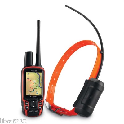
Garmin Astro 320 GPS-Enable Dog Tracking System (Astro 320, DC 40 Bundle)
U.S. Only – 010-00976-00
BRAND NEW -- NOT REFURBISHED
See Your Dogs' Every Move
The Astro system includes the redesigned Astro 320 and the rugged,
orange polyurethane DC 40 transmitter collar. The collar accommodates
most e-collar receivers, eliminating the need to put two separate
collars on a dog. Plus, Collar Lock creates a 4-digit PIN number that
helps prevent others from seeing your dog's whereabouts — a useful
feature in field trials to ensure that an Astro is used only as a
recovery tool when a dog in competition becomes lost.
To get started, just take Astro outdoors and turn on the handheld and
transmitter to acquire GPS satellite signals. Then attach the DC 40 to
your dog. Now you're ready to turn him loose — no other setup required.
Experience the Improved Astro 320
More intuitive and easier to use, the new Astro 320 takes dog tracking
to an entirely new level. The interface streamlines what is displayed by
allowing dogs that are outside the current zoom level to have their
location notated in the display's margin. The user also can choose the
amount of each dog's tracklog displayed, or toggle it off completely, to
avoid cluttering the map.
The Astro 320, compatible with any Garmin DC series transmitter, also
debuts innovative features like enhanced map drawing capabilities,
BirdsEye Satellite Imagery compatibility (subscription required),
vibration-based alerts and a 3-axis electronic compass.
Thanks to the redesigned antenna, the maximum range between the Astro
320 and a Garmin tracking collar has been increased by nearly 30 percent
– up to 9 mi in flat, unobstructed terrain.
Both durable and waterproof, Astro 320 features the legendary toughness
that's built to withstand the elements – be it dust, dirt, humidity or
water, none of which are a match for this essential hunting companion.
Upgrade with Ease
Getting what you need for the hunt is now a little easier. Hunters have
the option of purchasing the entire Astro bundle, a stand-alone Astro
320 or as many DC 40 collars as necessary. And if you do get the 320,
remember it's compatible with every DC series dog collar.
Get Additional Mapping
With its microSD card slot, Astro 320 lets you purchase and load TOPO
U.S. 24K maps for land elevation contours or City Navigator NT map data
for turn-by-turn routing on roads (see maps tab for compatible maps).
Astro 320 also supports BirdsEye Satellite Imagery (subscription
required), that lets you download satellite images to your device and
integrate them with your maps. Mapping depicts important nearby
geographical features – and lets hunters know, for example, if their dog
has crossed a creek or is nearing a dangerous road.
In addition, Astro 320 is compatible with Garmin Custom Maps, free
software that transforms paper and electronic maps into downloadable
maps for your device.
Track Dogs in Dense Cover
As often as every 5 seconds, your dog's DC 40 transmits his position to
your handheld, and you can see his current location and a trail of where
he's been on the map page of your handheld. Switch over to the Dog
Tracker page to view a compass pointing to your dog's location as well
as his current status: whether he's running, sitting, on point or
treeing quarry. Astro also can sound an alarm to let you know instantly
when your dog goes on point.
Each dog's precise distance also can be presented on the map page, and
users can choose an option that auto zooms the map so all dogs can be
seen on the display at any time. Alternately, dogs that are too far away
to fit on the map's current zoom scale can be notated on the display's
margin in the direction of the dog's location. The user also can choose
the duration that each dog's tracklog is viewed on the display – or
toggle it off completely for a cleaner display.
Astro boasts a high-sensitivity GPS receiver that can track your dog's
position even in the densest cover. You can track up to 10 dogs at one
time with Astro, at a distance of up to 9 mi away (depending on
terrain). The system transmits information by line-of-sight, so it
reaches farthest in flat, open territory.
Count Your Coveys
After you've captured your quarry, mark the exact spot with Astro's
Covey Counter, a special waypoint that tells you the exact location,
time of day and elevation where you found your prey, as well as the
number of birds you flushed and took from that location. Astro lets you
save other special waypoints, such as "Truck" and "Lodge," so you can
save the location of these places quickly and easily for each hunt.
Astro also offers special waypoint icons to represent food plots, tree
stands and other hunting-related points.
Plan Your Next Trip
Take charge of your next hunting adventure with BaseCamp, software to
view and organize your maps, waypoints, routes, and tracks and send them
to your Garmin device. This free trip-planning software displays
topgraphic map data in 2-D or 3-D on your computer screen, including
contour lines and elevation profiles. It also can transfer an unlimited
amount of satellite images when paired with a BirdsEye Satellite Imagery
subscription as well as geotag photos, or associate them with specific
waypoints.
Features:
Customizable Dog Display: Tracking man's best
friend has never been so easy. WIth the 320, you can choose to see a
combination of your dog's name, direction, distance and status so you
can see everything without leaving your map.
Stay Up-to-date: Your dog covers some serious
ground, but you don't need to. Stay focused on where you're going, while
keeping up-to-date on your dog, even when he or she has gone off
screen.
Share Dogs: Need to share your dog with a pal?
No worry. Wirelessly send, receive or transfer a dog's name, ID and
update rate between units. You can track up to 10 dogs at a time, at a
distance of up to 9 mi away (depending on the terrain).
Activity Logging Keep track of what you did,
when you did it, with Astro's improved calendar. It automatically and
conveniently links all of your marked points and logged tracks to the
day of the hunt for later review, or bragging rights.
Dashboards: Bring more functionality to your
device with more dashboards in more places. View your elevation plot,
coordinates, compass arrow and more on any page, at any time.
Improved Interface: Bigger and bolder, the 320
uses larger icons and text so you can find what you're looking for
faster. Plus, the interface streamlines what is displayed by allowing
dogs that are outside the current zoom level to have their location
notated in the display's margin.
The Big Dog Just Got Better:
Uses HotFix and a high sensitivity receiver to acquire satellites
Offers an improved base map with Digital Elevation Model
Offers improved mapping support with access to TOPO U.S. 24K,
BirdsEye Satellite Imagery, Garmin Custom Maps, City Navigator NT,
BlueChart g2 and more (sold separately)
Allows you to adjust your dog's track length
Zooms in (and out) quickly to find your dog
Tracks 10,000 points of information per dog, ensuring your records are accurate no matter how long you are out
Uses a universally accepted GPX file format to store all of your data
Includes a keypad lock to stop accidental key presses
Allows you to switch profiles - hunting, recreational,
automotive, marine, geocaching, fitness, etc. - quickly so you won't
miss a beat once you're done hunting
Debuts innovative features like enhanced map drawing capabilities, vibration-based alerts and a 3-axis electronic compass
Features legendary toughness that's built to withstand the elements – be it dust, dirt, humidity or water
Marks your exact spot with Covey Counter, a special waypoint
that tells you the exact location, time of day and elevation where you
found your prey
Saves other "special" waypoints, such as "Truck" and "Lodge" as
well as waypoint icons to represent food plots, tree stands and other
hunting-related points
BRAND NEW -- NOT REFURBISHED
| For more selection in this category, click link below |
|
|
|