|
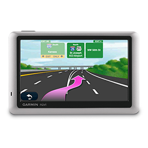
Garmin International is pleased to announce the nüvi 1450T GPS navigator. The 1450T features a large 5-inch screen and an ultra-thin design, as well
as popular features like lane assist with junction view and spoken street names. The 1450T also includes an integrated lifetime traffic receiver power
cable. Note: nüvi 1450T includes all of the features that come standard with the popular nüvi 1490T, except Bluetooth® hands-free calling. Product Features and Specifications - Bright 5"e; diagonal color display ? 480 x 272 pixels, WQVGA TFT display with white backlight
- Sleek, ultra-thin design
- Easy-to-use, touchscreen with a new enhanced interface
- Includes turn-by-turn directions with spoken street names ? ?Turn right on Main Street"e;
- The map data is provided by NAVTEQ, a world leader in premium-quality mapping
- Lane assist ? navigate with confidence while nüvi directs you to the preferred lane
- Junction view ? view realistic images of upcoming junctions where available
- Multiple point routing with route planner
- ecoRoute™ ? view suggestions for fuel-efficient navigation, conserving both money and fuel
- High-sensitivity GPS receiver with HotFix®
- Enhanced pedestrian navigation ? navigate using public transportation, such as bus, metro and suburban rail systems with optional cityXplorer™
content. Available for download and purchase at www.garmin.com - Speed limit indicator ? unit displays speed limits for most major roads
- Trip computer records mileage, maximum speed, total time and more
- Built-in travel kit includes picture viewer, world clock, currency and measurement converters and calculator
- microSD™ memory card expansion slot
- Includes Garmin Lock™ anti-theft feature
- Configurable vehicle icons ? select fun, customized vehicle-shaped icons; download additional choices from www.garmingarage.com
- Offers 3-D mapping perspective, or 2-D overhead view
- Built-in lithium-ion battery ? lasts up to four hours depending on usage
- Includes sturdy suction cup mount with easy adjustment and quick release
- Simplified connectivity, using USB mass storage, access either the microSD card slot or the unit?s internal memory directly from your computer
- POI loader program ? set up proximity alerts for school zones, create custom POIs and more
- Garmin Connect™ Photos ? associate your favorite images with saved locations. Visit http://connect.garmin.com for additional information
- Digital Elevation Model (DEM) maps show you shaded terrain contours at zoom levels of five miles and above
- "Where Am I?" feature ? find the closest hospitals, police stations, gas stations, nearest address, intersection and coordinates
- Auto time zone ? nüvi will automatically adjust your time zone
|