|
|
|
|
GPS Receiver + Location Finder + Data Logger + Photo Tagger
Condition: New
Price: $75.00

|
|
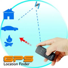
GPS Receiver + Location Finder + Data Logger + Photo Tagger gives you four powerful GPS functions in one small device!
If you have ever had trouble finding your car after a big football
game, you will love this gadget! Using the GPS location finder to find
your way back is easy. Before you leave your car, just press the button
for two seconds to save the location's coordinates. You can now enjoy
the game without worrying about remembering where you parked your car.
When you need to find your car again, just follow the red LED pointing
toward the saved position. When you come within 50 meters of the saved
location, the arrow will begin flashing, and when you are within 15
meters the arrow will turn blue. This smart function is great for
anyone who needs help finding his way back to his car, hotel, or wife.
But wait, there's more. This gadget can also turn your
computer into a GPS system! This USB GPS receiver dongle is the only
hardware you need to transform your laptop, notebook, or netbook
computer into a fully functioning GPS unit. Just connect this dongle to
your computer's USB port and locate your position right on your screen.
This is great for finding your place on a map when you're camping or
planning the next day's route.
You can also use this GPS receiver's data logger function to
record all the GPS data of your trip. The data logger records your
position, speed, and altitude. When you get home, connect the dongle to
your computer and use the included iTravel Data Logger software package
to view all your logged paths right on Google Maps or Google Earth.
This powerful, easy to use software lets you view data such as the
start time, end time, duration, and distance of each path, as well as
your speed, altitude, and GPS coordinates at every point along your
path.
Now the fun really begins! Use the included software to paste your
photos and captions onto your path. Next, embed GPS info into your
pictures and upload them to Flickr. Now your family and friends all
over the world can see your pictures and the exact location where you
took them!
Four-in-one functionality and an unbeatable factory-direct
price make this USB GPS receiver a great choice for GPS enthusiasts,
travellers, and anyone who wants to experience all the thrill of
getting lost in the woods but none of the danger.
At a Glance...
- Model CVHN-G50 GPS Receiver + Location Finder + Data Logger + Photo Tagger
- Ultra portable 4 in 1 GPS USB dongle for laptops and notebooks
- Location Finder guides you to your saved positions
- Data Logger records GPS coordinates, speed, and altitude as you travel
- Photo Tagger lets you share your geo-tagged photos with family and friends on Flickr
- GPS Receiver lets you turn your laptop, notebook, or netbook into a GPS system
- View your paths on Google Maps or Google Earth
This GPS receiver is compatible with all major brands of GPS
computer software. This model includes excellent user-friendly software
for the data logger and photo tagger functions. This model does not
come with any GPS navigation map software.
GPS Receiver Specifications
- Primary Function: Four-in-one GPS location finder, receiver, data logger, and photo tagger
- Eight LEDs indicate direction clearly
- Able to record point of interest (POI)
- Switch between Location Finder and Data Logger modes
- Chipset: Skytraq Venus 6
- Frequency: L1,1575.42 MHz
- C/A Code: 1.023MHz
- Channels: 65-Channel all-in-view tracking
- Tracking Sensitivity: -160 dBm
- Re-acquisition: -157 dBm
- Accuracy
- Horizontal Position: 10m 2D RMS (without SA)
- WAAS Enabled: 5m 2D RMS(without SA)
- Time: 1 micro-second synchronized to GPS time
- Velocity: 0.1m/sec 95% (without SA) - Datum: WGS-84
- Acquisition Rate
- Hot Start: 1 sec.
- Warm Start: 25 sec.
- Cold Start: 29 sec.
- Reacquisition: < 1 second - GPS Output data: NMEA-0183 V3.01; SkyTraq Binary
- Operation Range:
- Max Acceleration: Up to 4G
- Max Altitude: Up to 18,000 meters
- Max Velocity: Up to 515 meters/sec. - USB: Mini-USB port and cable included (for GPS receiver mode and recharging)
- Power: 650mAh Li-ion rechargeable battery
- Battery Life: 14 hours usage
- Temperature
- Operating: -20 to +60 degrees Celsius
- Storage: -20 to +80 degrees Celsius
- Humidity: Up to 95% non-condensing - Output Data Format: WGS 84
- Log Interval: By time (1 sec. to 30 mins) or distance (1 to 65,535 meters)
- Memory: Store up to 100,000 records in flash memory (8M bits)
- Dimensions: 74 x 29 x 22 mm (L x W x H)
- Log Data: Longitude, Latitude, Speed, Altitude, UTC
- Interface: USB port
- Color: Black
- Certifications: CE, FCC, RoHS
- Manufacturer Ref: CLSK3B5QID
Software Functions
- View in Google Maps or Google Earth
- Upload photos to Flickr and Flickr Maps.
- View multiple paths simultaneously.
- Adjust color and width of tracks.
- Display speed and altitude graphed against time.
- View speed, alitutde, and GPS coordinates at any point on your path.
- Add photos, videos, audio files, comments, and place names to any point on your track.
- Write GPS info into photos.
- View slideshow of your photos.
- Shift photo date and time
- Easy track editing.
- Display distance in metric or imperial units.
- Display GPS coordinates in Degrees or Degrees, Minutes, Seconds
- Detects GPS devices quickly and automatically
- Configure GPS device to log by intervals of time (every 5 sec.,
every 10 sec., etc.), distance (every 5 meters, 10 meters, etc.) or
speed (over 8 km/hr, over 25 km/hr, etc.). Can be configured to log
when one condition is met (e.g. create a log every 3 seconds) or only
when multiple conditions are met (e.g. create a log every 10 meters
when speed is greater than 60 km/hr).
- Export your paths as .KML, .NMEA, .GPX, or .CSV files to share your trips with your family and friends.
- No fees/subscriptions: Included software is free and requires no subscription for any of the above functions.
- Languages: English, Spanish, French, German, Dutch, Italian,
Portuguese, Russian, Thai, Korean, Japanese, Simplified Chinese,
Traditional Chinese.
- Compatibility: Windows XP and Vista (32 bit version only)
- Free updates
Product Notes
- This GPS dongle is compatible with most brands of GPS
software - however hardware specific software such as Garmin may not
run on this unit. As the wholesaler, Chinavasion provides the
GPS-enabled hardware only, not the software. Chinavasion provides no
warranty or customer support regarding GPS software. Chinavasion cannot
provide downloads / links / advice regarding GPS software. Any software
installation you undertake should be performed or supervised by a
professional.
- GPS data logger and photo tagger functions requires only this device and the free included sotware: no subscriptions, no fees!
- Accurate within up 1 to 5 meters
- Low power consumption
- Quick reacquisition of satellites
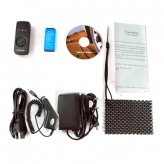
Package Contents
- Model CVHN-G50 4 in 1 GPS Location Finder, Receiver, Data Logger, Photo Tagger
- CD with iTravel Photo Tagger software and English User Manual
- Car Cigarette Adapter
- USB to mini USB cable
- Rechargeable Li-ion Battery (680mAh)
- Power Adapter (100-240V 50/60hz)
- User Manual - English
- Wrist Strap
- Dashboard Pad
FAQ - Frequently Asked Questions
- Can I use this to device to find a person?
Only if they don't move. This GPS location finder saves the coordinates
of a location, then uses satellite triangulation to guide you back to
that location. It is most useful for finding your way back to your car,
hotel, or camp. - Can I just plug this USB dongle into my laptop and start using GPS navigation right away?
In addition to this USB dongle, you will also need to install GPS
navigation software (not included with this GPS receiver) on your
computer. Once your computer has GPS software, then you are ready to
plug in this GPS receiver and start driving. - The software sounds like it can do a lot: show your recorded paths,
add pictures, and upload geo-tagged pictures to Flickr. How can it do
all that? And is it hard to use?
The included software is extremely user-friendly and easy to use. Every
one of its great functions requires just one click of your mouse. Plus,
it's free!
|
Return
Items must be returned within 30 days .
Refund will be given as Money back.
Refund policy details:
All our products come with a one year manufacturer's warranty and we accept returns up to 30 days. Please make sure to contact us before returning any products.
Shipping
Destination: United States |
|---|
|
| USPS | First Class® | $0.00 | $0.00 | |
Payment Method
Type | Instructions to Buyer |
|---|
| Paypal | |
Insurance
Not Offered (Domestic)

|
|
|