C-MAP NA-M026 C-CARD FORMAT GREAT LAKES AND THE MARITIMES
Condition: New
Price: $184.49

Description:
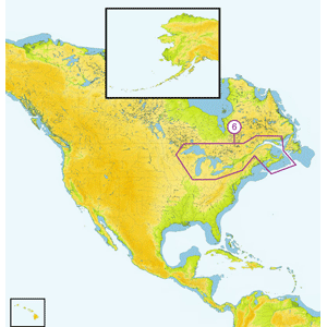
NA-M026 => Great Lakes, Northeast Coast and Approaches
Coverage of the Great Lakes, St. Lawrence River and Northeast United States. Coverage of the Great Lakes also includes Fox River and Lake Winnebago, Lake St. Clair, Rideau Canal, Ottawa River and the Trent-Severn Waterway. Includes all coastal charts for New Brunswick and Nova Scotia in Canada and Maine, New Hampshire, Massachusetts, Connecticut and New York in the U.S. Also included is coverage of the Hudson River and Lake Champlain as well as the Erie Barge Canal.
| Return Policy: | Items must be returned within 14 days .
Refund will be given as Money back.
Refund policy details:
You may return a defective product up to 14 days after receive it. NO REFUNDS WILL BE AUTHORIZED AFTER 14 DAYS. Case lost must be returned in the original shipping carton with all individual items un opened. No partial returns will be accepted. All return require a Return Merchandise Authorization Number(RMA#) which is good for 14 days. No return will be accepted without an RMA#. If you dicide to return undamaged or non-defective products, you will be responsible for 20% restocking fee. |
| Shipping: | Destination: United States |
|---|
|
| UPS | Ground | $15.00 | | |
|
| Handling: | $0.00(Domestic)
$0.00(International) |
| Insurance: | Not Offered (Domestic)
|
|