|
|
|
|
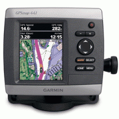
GPSMAP 441 GPS CHART PLOTTER
GARMIN
Price: $499.99

|
Features an ultra-bright 4" QVGA display along with an improved high-speed digital design for faster map drawing and panning speeds. Plus, this waterproof unit has a high-sensitivity internal GPS receiver, so mariners will always know their position at sea. It's ready to go with built-in BlueChart g2 marine cartography of the coastal united states - including Alaska, Hawaii and Explorer Chart data of the Bahamas. Mariners can navigate the open waters with ease knowing that these new units include Garmin's proven easy-to-use interface design.
Features and Specifications:
- Ultra-bright 4" diagonal QVGA display, 240 x 320 pixels - over 800 nits of brightness
- NMEA 2000 certified for seamless integration with the Garmin marine lineup
- Preloaded worldwide marine basemap
- Compatible with GXM 51 for XM Satellite Radio and XM WX Satellite Weather
- Built-in high-sensitivity GPS receiver
- High-speed processor for fast screen redraws and smooth panning
- Streamlined user interface makes it simple to select modes and features
- Single SD memory card slot for BlueChart g2 Vision cards, as well as saving waypoints, routes and tracks to an SD card
- Optional BlueChart g2 Vision cards provide marine chart detail and enhanced navigation features like Auto Guidance, satellite imagery, 3-D Mariner's Eye View and 3-D Fish Eye View
- Backlit keypad for easy operation in low light conditions
- Unit dimensions: 5.0"H x 5.7"W x 2.7"D
|
Items must be returned within 14 days .
Refund will be given as Money back.
Refund policy details:
Destination: United States |
|---|
|
| STANDARD | Economy | $13.00 | | |
Type | Instructions to Buyer |
|---|
| Paypal | |

|
|
 Shopping Cart